New Westminster Secondary School Replacement Project
About the NWSS Site
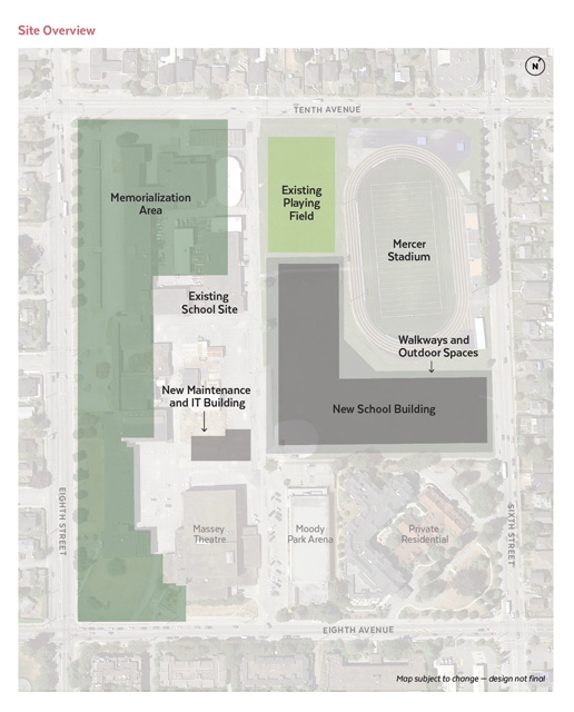
The New Westminster Secondary School is located on the southeast section of the city block bordered by Tenth Avenue, Eighth Street and Eighth Avenue in New Westminster. The current school is adjacent to Mercer Field and Stadium, Moody Park Arena and Massey Theatre, all of which will continue to serve the community once the new school is built.
History
During the early years of New Westminster, some areas of the property were used as burial grounds. The Chinese community in particular have a deep connection to the property, as original Chinese settlers would have been buried in what was then called the New Westminster Public Cemetery. The cemetery began as a small one-acre site on Douglas Road (now Eighth Street) in 1861. As demand increased, the cemetery was expanded, with new lands being cleared for use by both city and provincial institutions.
Protected Areas
Both the Government of British Columbia and the New Westminster School District made a commitment to protect and preserve the historical significance of the site and to ensure that no construction will take place on any known burial areas. The New Westminster Secondary School Replacement Project is dedicated to meeting this commitment.
To confirm buildable locations for the new school, Golder Associates, on behalf of the School District, conducted a heritage investigation and archaeological impact assessment of the project site in 2016. Based on previous and recent studies, we are satisfied that there are no known burial areas in the anticipated location of the new school.
Heritage management and archaeological monitoring procedures will remain in place throughout the construction of the new school.
2016 Heritage Investigation Results
Field investigations in and adjacent to the anticipated location of the new school, led by Golder Associates archaeologists, did not identify any burial areas or historic materials and features associated with past cemetery use.
Archaeological impact assessment activities took place on site between November 14 and December 13, 2016. Field investigations included the monitoring of geotechnical and geo-environmental boreholes located within and immediately adjacent to the archaeological site as well as mechanical testing of potential geophysical anomalies identified in an earlier study conducted from July 13 to August 23, 2016. The purpose of this second phase of work in late 2016 was to determine and locate the presence of any burial areas or historical artifacts.
Golder Associates has developed an interim report which details their archaeological impact assessment work and findings. The full report can be downloaded here.
Heritage investigations of the previously identified locations determined that the geophysical anomalies were typically objects such as boulders, tree stumps, metal objects, historical artifacts and past construction debris. These results are detailed in the report.
Given the historical cemetery use on the site and the large number of cultural groups and organizations associated with the site, the Heritage Conservation Act permit application was distributed widely to groups with an identified historical link to the site. Golder also applied for four First Nations heritage investigation permits, and representatives from First Nations groups also participated in the field work activities.
As committed, other areas of the site previously confirmed as being associated with past cemetery use will be memorialized through a passive park and memorial area. The Memorialization Advisory Committee will be engaged in determining how best to memorialize these dedicated and protected areas of the site.
Memorialization
We continue to engage with First Nations communities, the Chinese Benevolent Association, the Legacy Initiatives Advisory Council, Inclusion BC, and other organizations that represent communities with a history or potential history of ancestral burials on the site. A Memorialization Advisory Committee (MAC) has been struck and held its first meeting on June 12, 2017. The committee continues to meet every two to three months to discuss design components and to consider how best to memorialize the dedicated and protected areas of the site that are known to have been used for burials. The memorialization area is part of Phase 2 of the project and will be developed as a passive park, following the deconstruction of the existing school.